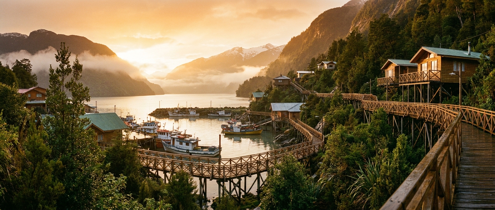
Caleta Tortel, Aysén, Chile
There are no roads in Caleta Tortel — around 7 km of raised cypress-wood boardwalks connecting stilt houses above a glacier-fed fjord. One of Patagonia's most remarkable expedition ports.
There are no roads in Caleta Tortel — around 7 km of raised cypress-wood boardwalks connecting stilt houses above a glacier-fed fjord. One of Patagonia's most remarkable expedition ports.
Caleta Tortel is an expedition-only port; there is no cruise terminal. Passengers tender to the main dock and immediately step onto the boardwalk network.
💡 Pro move: Wear sturdy, non-slip footwear. Some boardwalk sections have steep stairs and can be slippery when wet. Wheeled luggage is useless here.
Caleta Tortel has no cruise pier — all ships use zodiac or tender transfers to the village's main wooden dock.
| Cruise Line | Typical Berth / Arrival | Dock or Tender |
|---|---|---|
| Expedition lines (Silversea, Ponant, Seabourn, Hapag-Lloyd) | Anchor in Tortel Fjord; tender/zodiac to main dock📍 | Tendered |
| All other cruise vessels | Tender to main village dock📍 | Tendered |
Caleta Tortel's excursions center on the sea — boat trips to glaciers and historic islands are the highlights, with short hikes on boardwalks and nearby trails.
A full-day boat trip through the fjords of Bernardo O'Higgins National Park to reach the Jorge Montt tidewater glacier — a fast-receding river of ice at the edge of the Southern Patagonian Ice Field.
Find glacier tours →A short boat ride to the Island of the Dead, a National Historical Monument where about 33 weathered cypress crosses mark the graves of workers from the Baker Exploiting Company who died under mysterious circumstances in 1905–1906 while clearing a route through the wilderness.
Find island boat tours →A half-day hike up Cerro Vigía (also called Cerro Bandera) above the village for panoramic views of the Baker River Delta, surrounding mountains, and the fjord below. The trail mixes boardwalk, rock, and forest paths.
Find hiking tours →Boat trip through Steffen Fjord and up the Huemules River basin to the Steffen Glacier lagoon, the southernmost outlet of the Northern Patagonian Ice Field.
Find glacier boat tours →Wander the roughly 7 km of hand-built Guaitecas cypress walkways that ARE the village — past stilt houses, a small school, the harbor overlook, and local kiosks. Free and fascinating.
Self-guided walk →Walking in Caleta Tortel means the boardwalks themselves — there are no streets, and the entire village is your path.
Start at the main dock and follow the boardwalks uphill past the central plaza, the small church, and the upper residential terraces, then loop back along the lower waterfront boardwalk to the dock. The whole village is on this network.
📍 Open in MapsFrom the top of the village boardwalk, follow the trail through native forest to Playa Ancha beach and on up to Cerro Vigía for sweeping views of the Baker River Delta and fjord. Waterproof boots essential.
🗺️ See full route in Maps →Climate normals for Caleta Tortel, Aysén, Chile (2014–2023 averages). Pack for the month you sail — highs, lows, and how many rainy days to expect.
| Month | Avg High | Avg Low | Rainy Days |
|---|---|---|---|
| Jan | 58°F / 14°C | 46°F / 8°C | 25 |
| Feb | 60°F / 16°C | 47°F / 8°C | 20 |
| Mar | 56°F / 13°C | 44°F / 7°C | 23 |
| Apr | 52°F / 11°C | 41°F / 5°C | 21 |
| May | 47°F / 8°C | 38°F / 3°C | 21 |
| Jun | 41°F / 5°C | 33°F / 1°C | 22 |
| Jul | 41°F / 5°C | 33°F / 1°C | 22 |
| Aug | 42°F / 6°C | 35°F / 2°C | 25 |
| Sep | 45°F / 7°C | 35°F / 2°C | 22 |
| Oct | 48°F / 9°C | 37°F / 3°C | 22 |
| Nov | 52°F / 11°C | 40°F / 4°C | 23 |
| Dec | 57°F / 14°C | 44°F / 7°C | 26 |
Source: Open-Meteo ERA5 (10-yr daily averages)
Upcoming cruises that call at Caleta Tortel, Aysén, Chile. Dates, prices, and ports of call change — always confirm with the cruise line before booking.
Itineraries and prices change — always confirm with the cruise line before booking. Some links are affiliate links that may earn us a commission at no extra cost to you.